App Settings
Details here are for app version 5.70. There may be differences between app versions and between Android and Apple versions.
Layers
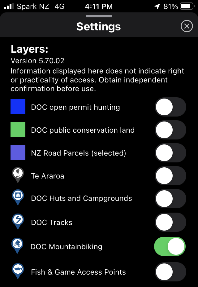
Layers are sets of data that can be displayed on the map. They are installed with the app and can be used off-line. Toggle them on or off as required. Note that some of the datasets are large and may take a few moments to display. Selecting a dataset also increases the memory required to run the app. Data displayed in these layers is current as of the time of data capture displayed on the Settings page in the app. It may not accurately represent recent or temporary changes in the data.
“DOC open permit hunting” represents the open permit hunting boundaries managed by DOC. Full details of the terms and conditions and confirmation of the boundary data is available on the DOC website. Other hunting blocks, for example those managed by regional councils, are not included with the app, but they can be imported if you source the relevant data (as kml of gpx files) independently.
“DOC public conservation land” is a dataset of all DOC managed conservation and national parks and public reserves.
“NZ road parcels” is a selected set of NZ road parcels that are adjacent to public conservation land. It is important that you know what NZ road parcels represent and have your own understanding of access rights before using this data. A good starting point is the NZ walking access commission.
“Te Araroa” is a set of data sourced from the Te Araroa website. It shows a trace and calculated altitude profile for the main Te Araroa routes.
Layers for DOC huts, campgrounds, tracks (walking), and mountain-biking tracks display details of the respective facilities managed by DOC. See the DOC site for further details, including where bookings are required.
“Fish and Game Access Points” shows access points listed by NZ Fish and Game.
Display Options
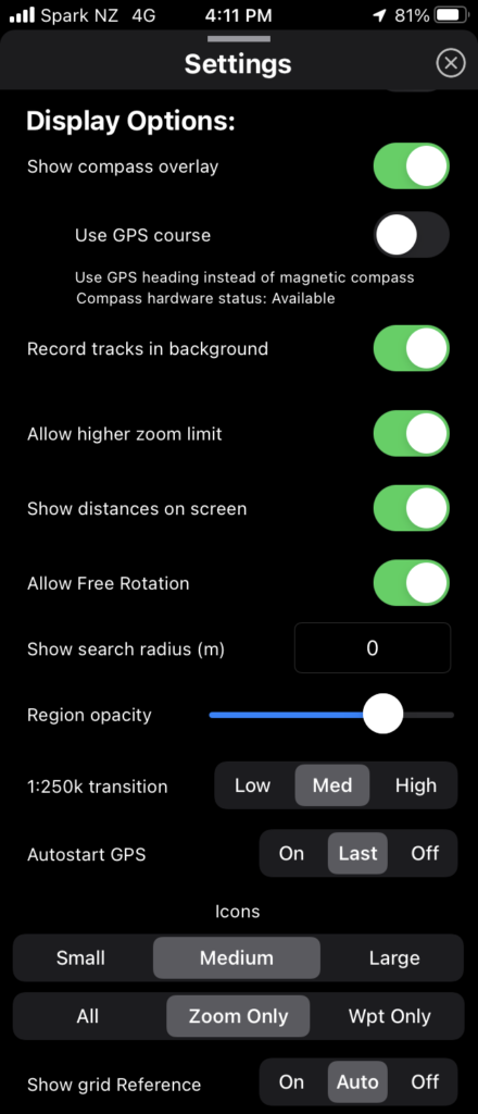
“Show Compass Overlay” enables a compass display at the top of the map. This gives an analog display of the orientation your phone is pointing, as well as indicators showing the relative bearing to the point the map is focused on and to the currently selected waypoint. This option will be unavailable if your device has no magnetic (compass) sensor.
“Use GPS Course” is an alternative option for calculating your orientation based on the direction you are moving instead of magnetic compass measurements. If you select this option then you will only get a useful bearing when you are moving sufficiently fast and will get no bearing or an inaccurate one when moving slowly or stationary. It is useful in some cases, for example driving, where it can be more accurate than magnetic measurements. Turn this option off to re-instate use of magnetic bearing measurements.
“Record tracks in background” is used when you are actively recording your track and switch to another app or switch off the screen on your phone. If selected then recording will continue. If de-selected then recording will pause until the app is activated again.
“Allow higher zoom limit” allows you to zoom further in on the map. The higher zoom exceeds the natural resolution of the 1:50k scale map and the image will be pixelated, but the higher zoom can be useful for navigation.
“Show distances on screen” displays a line on the map and a distance measurement from the center of the map to your GPS location (if GPS is on), and from the center of the map to the selected waypoint/track (if a waypoint or track is selected).
“Allow free rotation” enables the map to be rotated using manual finger gestures. Turn this off to lock the map orientation with North upwards.
“Show search radius (m)” is used to display a circle of a given radius around a selected waypoint. Enter ‘0’ to disable this feature.
“Region opacity” changes the opacity of the fill colour used to display regions. Lower values are more transparent.
“1:250k transition” changes the zoom point where the 1:250k maps change to the 1:50k map.
“Autostart GPS” changes the default behaviour when you open the app. ‘Off’ will start with GPS off, ‘Auto’ will start in the same state last used, and ‘On’ will start with GPS on. Regardless of this setting you can manually turn GPS on/off at any stage with the GPS on/off button on the main map screen.
“Icons”. These settings control the display of your waypoint and track icons on the map. The size can be changed between small, medium, or large. Icon visibility sets whether or not icons are displayed at all zoom levels or only when zoomed in further, and whether icons are only shown for waypoints and not tracks.
“Show grid reference” is used to configure a display on the main map screen that shows the grid reference and altitude for the center point that the map is focused on. This is displayed above the center point. A secondary display below the center point will identify built in regions (like DOC public conservation land) when hovering over them. The display can be turned on/off, or set to ‘auto’ which will display for a short period while moving the map and then fade away.
“Show over lock screen”. Android only. Allows you to interact with the app directly from the lock screen without needing to enter your pass code. Some activities such as attaching photos to waypoints or sharing data still require your pass code before they can be used.
Units
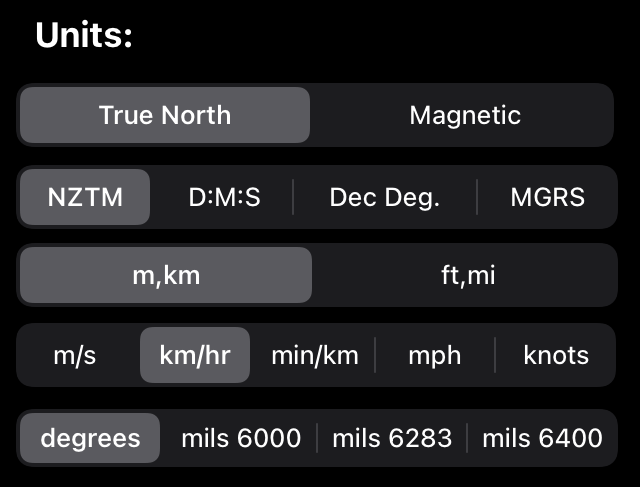
True north / Magnetic selects between using true north bearings or magnetic north bearings. This setting applies to all displayed compass bearings.
Units for grid references can be selected. The default is NZTM (New Zealand trans mercator, the current preferred New Zealand projection. Grid references are displayed as an Easting and a Northing from a fixed reference point). Longitude and Latitude on the WGS84 global datum can be used by selecting either D:M:S (displayed as degrees/minutes/seconds) or Dec. Deg. (displayed as decimal degrees). MGRS gives grid references in the Military Grid Reference System.
m,km or ft,mi or nautical selects whether to use metric or imperial units, or nautical units for any distances displayed.
Speed unit options include m/s, km/hr, minutes/km, miles per hour, or knots.
Angles or bearings can be displayed in degrees, or in ‘mils’ (milliradians) with 6000, 6283, or 6400 milliradians as the basis.
Track Recording Settings

‘Target accuracy’ sets the threshold for which GPS measurements are recorded when recording a track. In addition to calculating GPS position your phone also estimates how accurate that position is. If your phone estimates the position is less accurate than the setting value then the GPS position will be discarded and not recorded. This is useful if you want to avoid recording occasional inaccurate signals (which would make the recorded track look ‘jumpy’ and overestimate the distances travelled), however if GPS signals are weak (for example under heavy tree cover or in a gully) then setting this value too low may result in no GPS positions being recorded.
‘Min. distance’ sets the minimum distance you need to travel before a new GPS position is stored. Setting this to a low value will record more data points and can make the track more closely representative of your actual route. Setting it to a high value reduces the number of datapoints stored.
‘Min. timestep’ sets the minimum time between storing GPS datapoints.
Waypoint/Import/Export
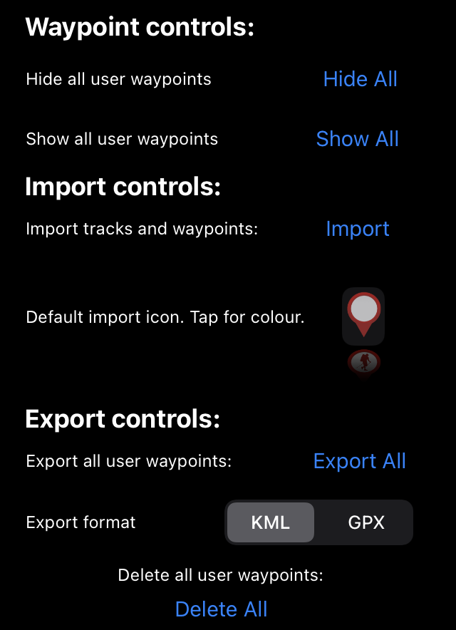
Waypoint settings can be used to hide or show all of your user waypoints and tracks. If you want to adjust the visibility of individual or selected groups of your data then use the options on the search page.
Import settings are used for importing data. This allows you to select a file in either GPX or KML format containing waypoints, track, or polygons and these will be added to your list of user objects that can be displayed on the map. If you choose a default icon and colour first then this will be applied to all imported object in that file, unless the file was created using the NZTopo50 app in which case the icon and colour used will be the one that was originally used in the app.
Export controls are used to create a file containing all of your user data. This is useful for sharing with other people or as a backup for your data. The file format can be either GPX or KML. To export (share) individual objects or groups of objects use the options on the search page. The file format selected in the options will be used in this case.
‘Delete all user waypoints’ will delete all of your waypoints (you will get a prompt to confirm). This can’t be reversed unless you have a copy of the data stored elsewhere. Built in data is not affected.
Other Settings
The remaining options on the settings page provide information on how to use the app, information on terms of use, information on the permissions that you have given for the app to use your GPS position, contact details (website, email, Facebook), an option to rate the app on the app store, and a copy of the LINZ 1:50k map legend.